| Talbot Green | |
| Although overlooked by the medieval town of Llantrisant, the 1841 tithe apportionment map of Llantrisant Parish and its accompanying schedule show us that no dwellings were located where Talbot Green village was later to emerge. According to the schedule Sir Charles Chetwynd Talbot, second Earl Talbot of Hensol, owned the land where development first occurred. | |
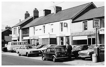
The Talbot Arms - Talbot Green |
It’s not surprising therefore that the Talbot Arms, the first dwelling to be built in the village in 1859, was named in his honour. As well as identifying the public house, the 1861 census also shows us that the name Tonsciborau (sic), Tonysguboriau, which means barns in an unploughed field, was applied to some of the area’s dwellings. A couple of barns appear to have been built on land owned by the Marquis of Bute near the junction where the road to Llanharan branched from the main road between Llantrisant and Cowbridge. During the 1860s Talbot Green grew from a hamlet into a small village of one hundred inhabitants. |
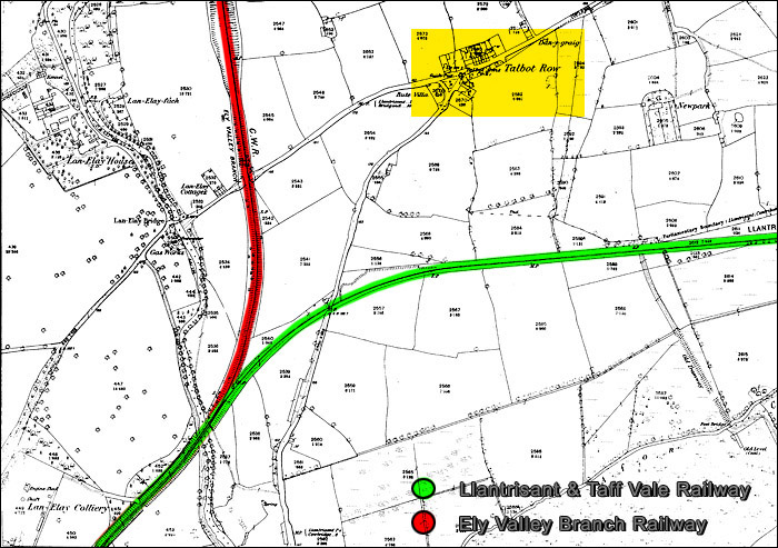
| Houses built on land that adjoined the Talbot Arms became known as Talbot’s Row. The village’s Welsh name has survived and the English name also remains although slightly altered. The catalyst for the development during the 1860s can be seen when examining the inhabitants’ occupations on the 1871 census. Among those listed are iron ore miner, engine driver, platelayer, carriage fitter and railway signalman. In Talbot Green’s vicinity, Bute Iron Ore Mine reopened in 1852 and Mwyndy Iron Ore Mine opened in 1853. Having acquired Mwyndy mine in 1856, Nash Edwards-Vaughan of Lanelay Hall was very much involved with promoting the concept of an Ely and Rhondda Valleys Railway Company. The Mwyndy branch of the Ely Valley Railway opened in 1859. Although it provided rail access to the mine, it did little to overcome the high cost of transporting the iron ore from the mines to the ironworks of the northern fringes of Glamorgan and Monmouthshire. The route to Merthyr was circuitous and required a lengthy detour via Neath and the Vale of Neath Railway. On August 2nd 1860 the main line of the Ely Valley railway from Llantrisant to Penrhiwfer opened. The same year saw the formation of the Llantrisant and Taff Vale Junction Railway. Five years later the company began a service between Cowbridge and Pontypridd via the Maesaraul Junction. As we can see from an 1875 ordnance survey map, both lines skirted Talbot Green. |
|
 |
|
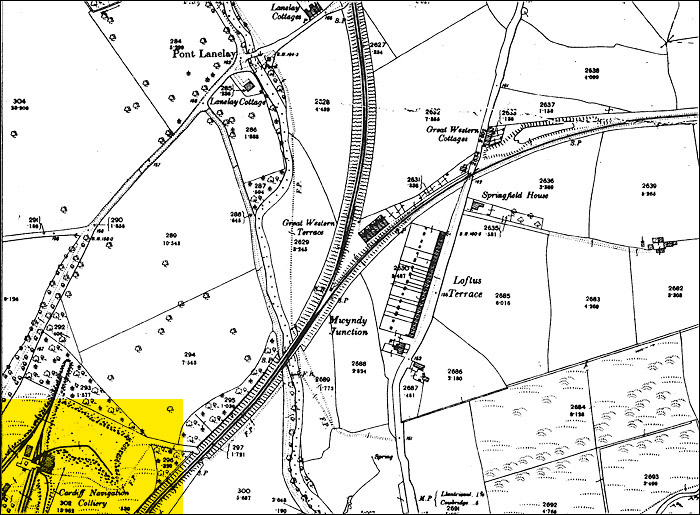
| Looking at the 1881 census, Talbot Green’s population had doubled during the 1870s reaching around 300. We can see from looking at the inhabitants’ birthplaces on the 1881 census that an influx of Cornish men and women had settled around the village and other parts of Glamorgan. The sinking of shafts to work the iron ore and the development of the coal industry was an obvious attraction to skilled miners whose futures in Cornwall looked bleak following the collapse of the copper mining industry. Another reason for the village’s growth was the opening of the Llantrisant Tin Plate works in 1872. As well as developing around the Talbot Arms, development began to occur further afield. Loftus Iron Company of Middlesborough invested heavily in the local colliery shown on the 1875 ordnance survey map including the building of 33 cottages known as Loftus Terrace. However the venture was unsuccessful and tinplate workers, as shown on the 1881 census, inhabited the cottages. Talbot Green’s population continued to increase reaching approximately 600 at the end of the nineteenth century. With the closure of the Bute iron ore mine in 1880 and Mwyndy iron ore mine four years later, the coal industry became the village’s main source of employment. The 1899 ordnance survey map shows that the local colliery was known as Cardiff Navigation. T.J. Masters, a Cardiff tailor and outfitter, who also leased Lanelay hall and is shown as residing there on the 1901 census, bought it. By this time, many of the village’s houses including those of Loftus Terrace were the homes of miners and their families. The rail industry continued to employ a number of the village’s workers. A group of houses known as the Great Western Railway cottages were located near the Mwyndy Junction and housed engine drivers, signalmen, railway guards and a railway crossing gateman. According to the 1901 census, Talbot Green’s small business community tended to reside in the village itself including a grocer, draper, china dealer, fish seller and a lady who ran a fancy shop. One gentleman on Talbot Road listed his occupation as being employed by the district council as an inspector of nuisance. |
|
1899 Ordnance Survey Map |
|
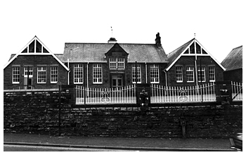
Tonysguboriau School, Original Buildings - April 1977
|
A primary school was erected in 1908 according to the 1914 Kelly’s Trade Directory. It was called Tonysguboriau School and was located near the village’s road junction. Another important event in the village’s development was the building of the Ely Valley Road in 1922-23 between Talbot Green and Tonyrefail. This created a new road junction at the village that gave a new momentum in its development. The new road encouraged the growth of bus services of which the main provider by 1939 was Rhondda Transport Company who established a bus station close to the junction. |
| In a publication entitled ‘Pontyclun & Talygarn: A History & Topography’, a local historian Mr J. Barry Davies writes that it was “frequently alleged, but not I believe, universally accepted, that it was a Rhondda Transport Inspector, Mr Frank Reed, who was instrumental in establishing the name of the village as Talbot Green rather than Talbot Road.” With improved transport facilities business began to expand. Penygraig Co-operative Society opened a store in 1932 on Talbot Road. Near the store in 1934 Llantrisant Motors established their original garage. | |
| Talbot Green’s transformation from a small village to a place of significant residential and commercial development occurred after the Second World War. Situated behind the houses that ran along the eastern side of Cowbridge Road, the first housing estates were Heol Johnson, Heol Miles, Fan Heulog and Bron Haul. Further housing was built at Forest Hill on the Lanelay Road, Maes y Rhedyn and the nearby grounds of Danygraig House. The house itself was taken over by the Llantrisant and Llantwit Fardre Rural District Council. Talbot Green’s further administrative status was further elevated when the magistrate courts that had formerly been held at the Town Hall Llantrisant moved to a new premises in the village. |
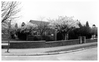
Magistrates Court, Talbot Road - April 1977 |
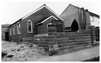 |
Also in 1956, a new secondary school called Y Pant was opened. A few years later a special needs school opened in 1964. The village’s only place of worship was opened in June 1958. Having set up a Sunday school based in a Nissen hut, Mr Edward Dickerson, who later became a full time church pastor, worked ceaselessly to open Ebenezer Free Evangelical Church. Left: Ebeneezer Free Evangelical Church - April 1977 |
| From the late 1960s onwards, Talbot Green has seen commercial development move to industrial estates and retail parks on the village’s peripheries. The road to Tonyrefail was again re-routed and extended and New Park Farm became a major retail centre with supermarkets and other commercial development in a growth pattern that shows no sign of slowing down. Recently Tesco demolished their old store and opened a new one. Other well-known high street names such as Marks & Spencers, Boots, Next and T K Max have followed soon afterwards. The business community located in the centre of the old village now faces a battle in the face of such stiff competition. | |