| Taffs Well | |||
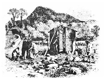
The name Taffs Well appears not to have been recorded on historical documents before the second half of the eighteenth century. Indeed, until the beginning of the nineteenth century, it was not a name given to a village, for there was none as such, but rather to an ancient warm water well and some farm holdings beside the River Taff. It's not known when the name Taffs Well was applied to the present village. However, it was the name given to the railway station of the Taff Vale Railway that opened in 1840. It also appears on the 1841 census. Right: An illustration showing the hut covering the warm water well for the privacy of its' occupants |
 |
||
 |
|||
| According to the 1841 census Taffs Well was inhabited by about 300 people, of which a third resided at the southern end of the village referred to as Walnut Tree. A striking feature of these records was the diversity of the population's occupations. They included farmers, publicans, milliners, shopkeepers, a butcher and a policeman. The village's greatest source of employment was the Glamorganshire Canal. As well as directly providing work for boatmen and lock keepers, it probably was of great importance to the villagers' carpenters, woodcutters and blacksmith. | |||
 |
The 1841 tithe map and its schedules for the parish of Eglwysilan is another source that provides valuable information about the early history of Taffs Well village and its surroundings. Two bridges are shown located to the south of the village, one crossing the Glamorganshire Canal and the other crossing the Taff Vale Railway. Above these bridges are Portobello Farm fields, some of them having been recently divided by the railway. Another farm shown on the map is Taffs Well Farm.
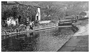
Left: The Glamorgan Canal at Taffs Well |
||
| Its fields stretch eastwards from the Taff River, crossing both the canal and railway while the farmhouse stands on the site presently occupied by Ty Bryncoch Flats. A well is clearly shown, although not named, in the field called Cae Ffynnon. (well field) Immediately above this field is a farm holding called Tir Ffynnon Taf. Although the dwelling remains today, the four fields that once were part of the farm are mainly occupied by Ffynnon Taf County Primary School and its recreation ground. Unsurprisingly much confusion was caused by the similar names of the two holdings. Taffs Well's population had more than doubled in 40 years according to the 1881 census. It also showed that although a significant number of its inhabitants continued to be shopkeepers, the majority now worked in the Pentyrch and Garth ironworks that were on opposite sides of the river or the Bryncoch and Rockwood collieries located on the village's outskirts. As a result of this expansion, schools and places of worship were established in the village. A National School known as Walnut Tree Bridge School opened in 1869. The building still exists today as St James Church in Church Street. There was also a British School that met in one of the village's chapels as well as a charity school for girls situated next to the Taff Well Inn. Following the formation of Eglwysilan School Board in 1871 a board school was started in the mid 1870s, and probably used the same premises as the former British School, until a new school was built and opened its doors on January 6th 1879. It continues to be the village school and recently enjoyed 125 years anniversary celebrations. |
|||
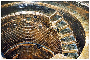
| Taffs Well Spring | |||
| Taff Well Spring, situated at the northern end of the village on the bank of the River Taff, remains one of the most remarkable relics of the Taff Valley. Its early history is shrouded in obscurity. A book published in 1833 states that it was "sometimes called 'Ffynnon Dwym' or the tepid well." It goes on to say, "an extraordinary flood in the year 1799 is said to have laid bare Roman masonry adjoining the well, which was covered by subsequent inundations of the River Taff." Although recent investigations failed to trace this masonry, the claim certainly has validity considering the proximity of Roman settlements and roads throughout the Taff Valley. According to the chemist Joseph Thomas, who surveyed the well in 1877, it had originally stood in the middle of green fields. However, the building of a weir across the river, which supplied water to the Pentyrch iron works, caused the riverbed to move eastwards. As a result, the well now bordered the river and was often covered in floodwater. Until the mid eighteenth century, the well was probably used on a purely local basis. Gradually, people began to travel from afar attracted by testimonies of the well's healing powers and aided by the building of the turnpike road, canal and railway. | |||
The well during restoration |
|
||
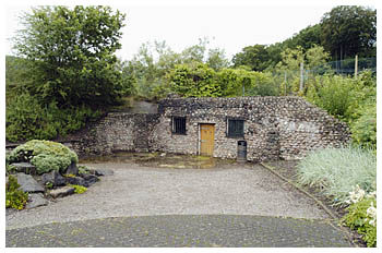
In more recent times, the well's waters rescued the village bowling greens from the effects of a drought in 1978. Interest in the well was rekindled and at the end of the seventies a campaign was launched to restore it and its surroundings. The well was cleaned out and several actually swam in its waters. However, it wasn't until the mid 1990s that a redevelopment of the area was completed. The building housing the well was given a new fascia and the swimming pool filled and replaced by a landscaped garden.
Right: The well building July 2004 |
 |
||
| Taffs Well Transport | |||
The canal near Taffs Well |
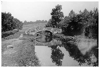
Taffs Well's geographical location ensured that communication and transport were important factors in its history and development. The village was situated in a narrow gorge on the route between Cardiff and the South Wales Valleys. It's not surprising therefore, that a canal, two roads and four railways should have passed through it, as well as the Taff river. On some occasions the river served as a means of communication but on others it became an obstacle for those who wanted to cross from one side to the other. We see from looking at the 1875 Ordnance Survey map that several fords existed up and down the river. One of these according to this map was situated near the present day police station. |
||
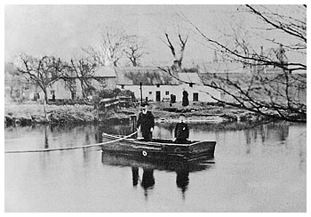
| However, before the building of any footbridges, the majority of those who crossed the river did so on one of the village's ferryboats. Pentyrch ferry, as it was known, crossed the river from the Junction Hotel while the landlord of the Portobello Inn operated another ferry. Both would have transported workers in the Pentyrch ironworks to and fro across the river from their homes in the Taff Well area. The ferry known as Taff Well ferry crossed the river from Ty'r Ffynnon farm, more commonly known as Ferry Farm located behind the school. The Saunders family ran Taffs Well ferry for many years. Tragically, Mrs Saunders was swept away and drowned while collecting a passenger in the early twenties. There were immediate calls for a footbridge. Mainly as a result of John Philips's generosity a bridge, after who it was named, was completed. Station Bridge, located at the Pentyrch Ferry crossing, had already been built at the turn of the century. |
Taffs Well ferry at Ty'r Ffynnon farm. The school can be seen to the right behind the tree branches |
||
| Walnut Tree Viaduct | |||
| Taffs Well was seen as an important communication link between the South Wales Valleys and the coast following the establishment of Merthyr's ironworks in the second half of the eighteenth century. The Merthyr-Cardiff turnpike road was built in the 1770s and the Portobello Inn at Taffs Well was one of the principal inns and staging posts along it. Despite these developments, Merthyr's ironmasters realised that horse drawn transport was not only slow and expensive but also handicapped the industry's expansion. With their financial support, the Glamorgan Canal began to be constructed in 1791. The section that ran through Taffs Well opened in 1794. Three of the canal's fifty-one locks, Taff Well Lock, Caegias Lock and Portobello Lock, were situated in the village. A short distance north of Taffs Well at Glan y Llyn were the impressive treble locks that had a rise of thirty-three feet. It wasn't long before the rapid growth of the iron industry placed an intolerable burden on the Glamorgan canal. It became obvious to the ironmasters that a railway from Merthyr to Cardiff needed to be built. The first section of the Taff Vale Railway opened in 1840 and included Taffs Well station. It was later renamed Walnut Tree Junction after the opening of the Rhymney Valley Railway connection with the TVR at Taffs Well in 1858. |
|||
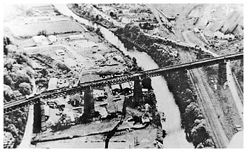 |
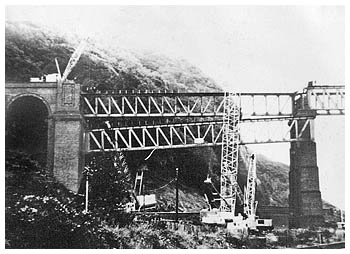
By 1880, the TVR and Rhymney Railway were so congested with coal traffic that coalowner David Davies established the Barry Dock and Railways Company in 1884 together with other frustrated coal owners. As the Barry Railway was one of the last private lines to be built in South Wales, it meant that considerable engineering work had to be undertaken, as earlier companies had chosen the more favourable and easier graded routes to the coalfields. Walnut Tree Viaduct, built in 1901, was an example of civil engineering brilliance.
Left: Walnut Tree Viaduct |
||
| Designed by Sir James Szlumper, the 120 feet high and 1548 feet long viaduct comprised of seven steel lattice girders spans resting on brick piers. It was slightly curved at its western end to enable the line to bend on to a shelf on the hillside. After dominating the southern end of the village for nearly 70 years, it was demolished in 1969 though two of its pillars still remain today. The last line to be built that ran past Taffs Well was Cardiff Railway. Although completed in 1911 it was used purely for local traffic because of TVR's refusal for the line to join its own line at Treforest. The Glamorgan Canal fell into disuse in 1942. On its site and that of the Cardiff Railway, the A470 trunk road, connecting Merthyr to Cardiff, was built in 1969. Only the TVR remains of the four lines that once passed through Taffs Well gorge. |
The demolition of Walnut Tree Viaduct in 1969
|
||